
สหราชอาณาจักร
HG5 รหัสไปรษณีย์
รายละเอียดรหัสไปรษณีย์
11 สถานที่รหัส
สถานที่
Arkendale
ภูมิภาค
England
เขต
North Yorkshire
พิกัด
54.0441, -1.4107
ความแม่นยำ
3 / 6
ประเทศ
สหราชอาณาจักร
ตำแหน่ง
OpenStreetMap ↗


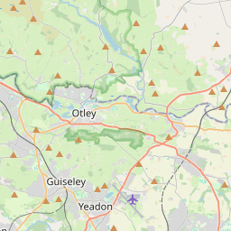


54.0441, -1.4107© OpenStreetMap
สถานที่ภายใต้รหัสนี้
11| สถานที่ | ภูมิภาค | เขต | พิกัด |
|---|---|---|---|
| Arkendale | England | North Yorkshire | 54.0441, -1.4107 |
| Clareton | England | North Yorkshire | 54.0133, -1.4584 |
| Coneythorpe | England | North Yorkshire | 54.0133, -1.4584 |
| Farnham | England | North Yorkshire | 54.0375, -1.4652 |
| Ferrensby | England | North Yorkshire | 54.0407, -1.4371 |
| Flaxby | England | North Yorkshire | 54.0142, -1.3957 |
| Goldsborough | England | North Yorkshire | 53.9833, -1.4167 |
| Knaresborough | England | North Yorkshire | 54.0091, -1.4685 |
| Scotton | England | North Yorkshire | 54.0288, -1.4993 |
| Scriven | England | North Yorkshire | 54.021, -1.468 |
| Staveley | England | North Yorkshire | 54.05, -1.45 |
รหัสเดียวกันในประเทศอื่น
0รหัสนี้ปรากฏเฉพาะในประเทศนี้เท่านั้น
FAQ
HG5 อยู่ในเมืองใด?
Arkendale, England, สหราชอาณาจักร
พิกัดของ HG5 คืออะไร?
54.0441, -1.4107
HG5 ถูกใช้ในประเทศอื่นด้วยหรือไม่?
ไม่
ข้อมูลไม่เป็นทางการและมีการตัดทอนที่ทราบอยู่แล้ว ตรวจสอบกับผู้รับและผู้ขนส่งสำหรับการจัดส่งที่สำคัญ ดูแหล่งที่มาและสัญญาอนุญาตของข้อมูล → · อัปเดต 2026-11-09 ดูการอ้างอิงที่